Snow, Sleet, Rain & Strong Winds Expected From Midnight Tonight Through Monday Morning
- Jan 16, 2022
- 4 min read
For The Rest Of Today: An area of high pressure will control our weather throughout the rest of today. This means that sunny skies are expected through early afternoon with an increase in cloudiness expected by late this afternoon. High temperatures this afternoon will be between 25 and 30 Degrees.
A Significant Storm System Will Bring Snow, Sleet, Rain & Strong Winds To Western & Central Mass From About Midnight Tonight Through Monday Morning: A storm system is expected to bring everything from a “thump” of snow from about midnight tonight until about sunrise Monday morning to a changeover to sleet and rain during the early morning hours of Monday to heavy rain and maybe a rumble or two of thunder during the rest of Monday morning. In addition, this storm will also bring some strong winds on Monday and Monday night.
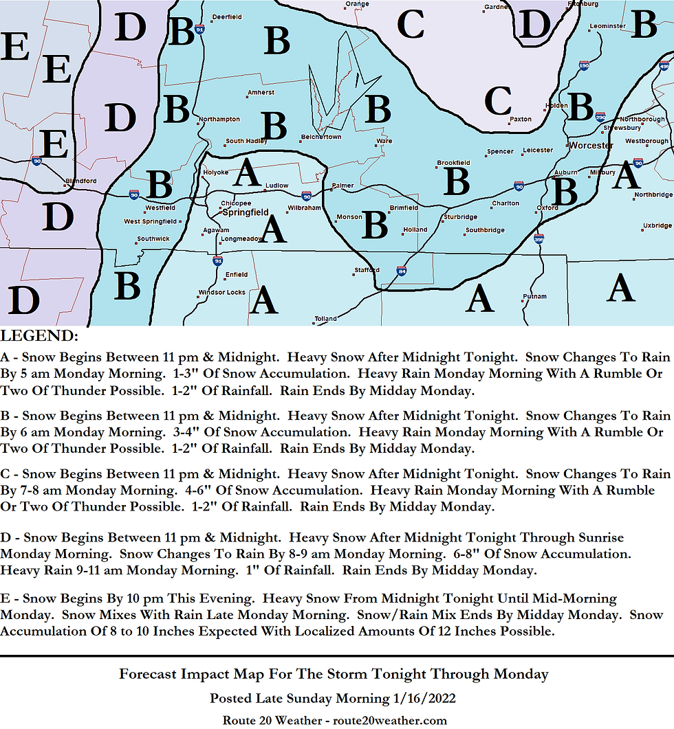
I will break this storm down more below. Also, if you would like to see how this storm will affect your area, please refer to the map attached to this post.
Snowfall Part Of This Storm: It is expected that snow will begin across Western Mass by about 11 pm this evening and then across Central Mass by midnight tonight. A period of heavy snow is then expected for a few hours after midnight tonight across all of Western and Central Mass. Snowfall rates of about 1 inch per hour is possible at times.
The snow is expected to hang on across the northern Worcester Hills, the western Hilltowns of Western Mass and the Berkshires for a few hours on Monday morning while other areas of Western and Central Mass change to rain around sunrise Monday morning. It is expected that the snow will change to rain in the northern Worcester Hills by 8 am, but could remain nearly all snow in the western Hilltowns of Western Mass and the Berkshires through at least mid-morning.
My forecast snowfall total map and what I expect in terms of weather can be found attached to this post.
Heavy Rain Monday Morning With A Rumble Or Two Of Thunder Possible: Several hours of heavy rain looks likely across a large part of Western and Central Mass during Monday morning, especially between about 6-7 am and 10 am. In addition, a squall line of sorts may pass through parts of Central Mass between 7 am and 9 am bringing with it a rumble or two of thunder and maybe some briefly very gusty winds. Rainfall amounts of 1 to 2 inches are expected during Monday morning and this will lead to areas of urban and poor drainage street flooding, especially since the ground is frozen and there’s likely to be snow and slush clogging many drains.
Strong Winds: Strong winds will also be a threat during Monday and Monday night.
On Monday morning, winds will be East to Southeast sustained at 15 to 25 mph with gusts to 40 mph at times.
During Monday afternoon, winds will be South sustained at 10 to 20 mph with gusts to 35 mph at times.
On Monday night, winds are expected to be West sustained at 20 to 30 mph with gusts of up to 40 to 50 mph at times.
Monday Night & Tuesday: Some scattered snow shower activity is possible during Monday evening with localized snow amounts of up to one inch possible. Skies will clear out late Monday night. Low temperatures Monday night will be near 20 Degrees.
Tuesday is expected to be a sunny and windy day with high temperatures between 20 and 25 Degrees. West winds will gust up to 40 mph at times on Tuesday.
Wednesday Through Friday: A frontal system is expected to push through the area by Wednesday night. Out ahead of this front, Wednesday is expected to be a cloudy day with high temperatures between 35 and 40 Degrees.
Snow showers will accompany the front during Wednesday night with localized snow amounts of up to one inch possible. Low temperatures Wednesday night will be near 25 Degrees.
Thursday is expected to be a partly sunny day with high temperatures near 30 Degrees.
Sunny to partly sunny skies are expected on Friday with high temperatures near 25 Degrees.
Next Weekend: There is ALREADY a storm system that I’m keeping an eye on as it could impact our weather sometime next weekend. Yet another low pressure system is forecast by all of the weather forecast guidance to take shape over the southeastern United States on Friday night and Saturday and head northeastward.
Some of the weather forecast guidance brings this storm system close enough to give the area accumulating snow on Saturday into Saturday night while other guidance shows a complete miss to the east. It’s WAY too early to tell which “solution” may be more correct. Either way though, just know that there will be a coastal storm lurking off of the New England coast next weekend. Whether it brings us impacts or not remains to be seen. Nevertheless, I will be watching things closely and will have updates as needed.
Comments